GarsGridGenerator Class
Generates and visualizes the GARS grid, the Global Area Reference System.
NuGet/Assembly: Carmenta.Engine.5.17.0.nupkg (in the CEOperators assembly)
Syntax
public class GarsGridGenerator : GeneratorRemarks
This generator creates the GARS grid, the Global Area Reference System for battle-space management designed by the US National Geospatial-Intelligence Agency (NGA).
Lawrence Nault. NGA Introduces Global Area Reference System. PathFinder, Nov-Dec. 2006.
Pete Renner. Global Area Reference System (GARS), 2006. https://www.uscg.mil/hq/cg5/cg534/nsarc/GARS_BRIEF.ppt
The GARS grid is based on a graticule (LongLat grid). Three sizes of LongLat squares have alphanumeric names:
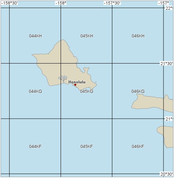
Squares that are 30 arc minutes large are called cells, and have a name consisting of a three-digit column number followed by a two-letter row identifier. The column numbers go from 001 to 720 between 180°W and 180°E. The row identifiers start from the south pole and are AA, AB, ..., AZ, BA, BB, ... BZ, ... QA, QB, ... QZ, excluding the letters I and O.
 |
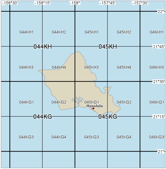
Squares that are 15 arc minutes large are called quadrants and their names have an additional digit in the range 1 to 4.
 |
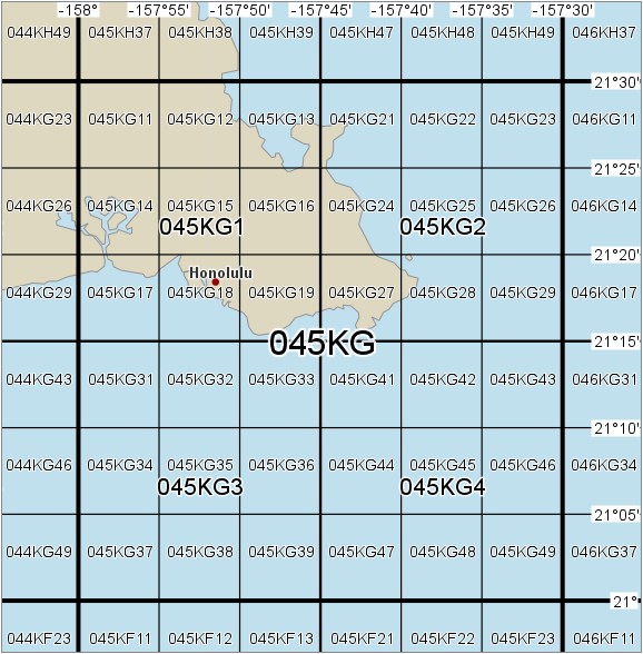
Squares that are 5 arc minutes large are called keypad key areas, or keys for short, and their names have yet another digit in the range 1 to 9.
 |
Squares of other sizes cannot be named in the GARS system, which means that GARS is not useful for navigation or targeting.
The GarsGridGenerator creates the GARS grid together with a scale-dependent visualization. You just have to attach a GarsGridGenerator to a OrdinaryLayer which you attach to your View, and if you like the default visualization, you are done.
Advanced Visualization
There are some generator properties that control the built-in visualization. For example, you can change color and font, and you can adjust the scale limits that decide when different kinds of labels are displayed. To make more advanced modifications of the visualization, you may have to override the built-in visualization by a VisualizationOperator with your own visualizers. In either case, it can be useful to know more details about the features and feature attributes that come from the generator.
The Generated Features
The generator can create line features and polygon features.
The labels for cells, quadrants and keys are carried as attributes of square polygon features, to which a TextVisualizer is attached.
The grid lines are represented by line features that carry their longitude or latitude as an attribute, and which get both a TextVisualizer and a LineVisualizer.
There is also another kind of line feature that is generated in the most zoomed-out scales: if the scale would not allow cell labels to fit inside their cells, the generator will instead place cell column labels along the south and north edge of the view, and cell row labels along the west and east edge of the view. These column labels and row labels are carried as attributes of special line features that go through their center of their column or row, and which do not get a line visualizer attached.
If you need to modify the default visualization, you can use some of the available feature attributes.
Line feature attributes
attribute name | possible values | meaning |
|---|---|---|
lineType | 0, 1, 2 or 3 | 0: a parallel that should be displayed. 1: a meridian that should be displayed. 2: a parallel that runs through the center of a cell row and carries a row label attribute; should not be displayed as a line. 3: a meridian that runs through the center of a cell column and carries a column label attribute; should not be displayed as a line. |
garsType | #keyLine, #quadrantLine, #cellLine, #cellColumn and #cellRow | A meridian or a parallel that is visualized as a line will have garsType = #keyLine if it separates GARS keys, garsType = #quadrantLine if it separates GARS quadrants, or garsType = #cellLine if it separates GARS cells. The invisible auxiliary lines will have garsType = #cellColumn if they carry a cell column label, or garsType = #cellRow if the carry a cell row label. |
degrees | A string | The latitude of a visible parallel (with lineType = 0) or the longitude of a visible meridian (with lineType = 1), formatted according to LongLatFormat. |
value | A string | A GARS cell row label attached to an invisible parallel (with lineType = 2), or a GARS cell column label attached to an invisible meridian (with lineType = 3). The default visualization will display these labels near the map window margins if MaxCellLabelScale ≤ View.NominalScale < MaxScale. |
impactAngleAtStart | A double, usually between 0° and 90° | The angle between the line start and the edge of the map. |
impactAngleAtFinish | A double, usually between 0° and 90° | The angle between the line end and the edge of the map. |
startType | #left, #bottom, #right, #top, #interior | Tells where a line feature starts (lines go eastward or northward). |
finishType | #left, #bottom, #right, #top, #interior | Tells where a line feature finishes (lines go eastward or northward). |
lineWeight | 1, 2 or 3 | This attribute is attached to the visible lines of the graticule. Its value depends on both view scale and garsType, and it can be used to select line width; see Table 3 below. |
garsLabelWeight | 1, 2 or 3 | This attribute is attached to the invisible auxiliary lines. Its value depends on both view scale and garsType, and it can be used to select GARS label size; see Table 3 below. |
Polygon feature attributes
attribute name | possible values | meaning |
|---|---|---|
garsType | #key, #quadrant or #cell | A polygon feature that represents a LongLat square will have garsType = #key, #quadrant or #cell, depending on its size. |
value | A GARS label | The GARS label for a key, quadrant or cell. |
height | An integer | The height in pixels of a polygon feature representing a LongLat square, if it were clipped to the view area. (The polygon will not really be clipped, but you may want to use PointVisualizer.ClipToViewArea = True.) |
width | An integer | The width in pixels of a polygon feature representing a LongLat square, if it were clipped to the view area. (The polygon will not really be clipped, but you may want to use PointVisualizer.ClipToViewArea = True.) |
garsLabelWeight | 1, 2 or 3 | A weight that depends on both view scale and garsType, and which can be used to select GARS label size; see Table 3 below. |
The weight attributes
The weight attributes depend on both feature type and view scale, and can be used when you want to define your own Font or LineWidth. The weight attributes are usually better for this purpose than the garsType attribute, because the garsType would say only that a certain line represents GARS cell borders, for example, but you need to know whether the line needs extra width, and this depends on whether quadrant borders and key borders are displayed in the current view scale.
garsLabelWeight of cell labels, or lineWeight of cell borders | 3 | 2 | 1 |
garsLabelWeight of quadrant labels, or lineWeight of quadrant borders | 2 | 1 | N/A |
garsLabelWeight of key labels, or lineWeight of key borders | 1 | N/A | N/A |
Inheritance Hierarchy
System.Object
EngineObject
Operator
Generator
GarsGridGenerator
Platforms
Windows, Linux, Android
See Also
Reference
Operators Module
GeorefGridGenerator
GridGenerator
UtmGridGenerator
Crs.FormatGars
Crs.ParseGarsAsArea
GarsGridGenerator Members
The GarsGridGenerator type has the following members.
Constructors
| Name | Description |
|---|---|
| GarsGridGenerator | Initializes a new instance of the GridGenerator class. |
Properties
| Name | Description |
|---|---|
| Description | Gets or sets a short description of the operator. Inherited from Operator |
| DisplayName | Gets or sets a display name for the operator. Inherited from Operator |
| Font | Gets or sets the font used by the generated text visualizers. |
| IsDisposed | Gets a value that tells whether the current GarsGridGenerator has been disposed. Inherited from EngineObject |
| IsoMetadataDocument | Gets or sets the path to an ISO 19139 metadata document for the operator. Inherited from Operator |
| LineColor | Gets or sets the color for the meridians and parallels. |
| LineWidth | Gets or sets the line width for the meridians and parallels. |
| LongLatFormat | Gets or sets the format for the longitude and latitude labels. |
| MaxCellLabelScale | Gets or sets the maximal scale for the generation of interior cell labels. |
| MaxKeyScale | Gets or sets the maximal scale for generating key areas and key labels. |
| MaxQuadrantScale | Gets or sets the maximal scale for generating quadrants and quadrant labels. |
| MaxScale | Gets or sets the maximal scale for generating anything. |
| Name | Gets or sets the name of the operator. Inherited from Operator |
| NativeHandle | Gets the native Carmenta Engine kernel object the current GarsGridGenerator represents. Inherited from EngineObject |
| TextBackgroundColor | Gets or sets the background color for all text labels. |
| TextColor | Gets or sets the color for all text labels. |
| TextHaloColor | Gets or sets the color for all text halos. |
| TextHaloWidth | Gets or sets the width for all text halos. |
| IUserProperties.UserProperties | Gets the AttributeSet that contains the user properties. Inherited from IUserProperties |
Methods
| Name | Description |
|---|---|
| Clone | Creates a copy of an object. Inherited from EngineObject |
| Dispose | Releases the reference to the native Carmenta Engine kernel instance the EngineObject represents. Inherited from EngineObject |
| Equals | Determines whether this instance is equal to another. Inherited from EngineObject |
| FindChildObject | Overloaded. Finds the child object with the specified name. Inherited from Operator |
| FlushCache | Removes the objects that have been cached by the operator. Inherited from Operator |
| GetChildObjects | Overloaded. Gets the child objects of the current object. Inherited from Operator |
| GetFeatures | Overloaded. Gets features from the operator chain. Inherited from Operator |
| GetLocalizedDescription | Gets a localized version of the operator description in a specific language. Inherited from Operator |
| GetLocalizedDisplayName | Gets a localized version of the operator display name in a specific language. Inherited from Operator |
| GetLocalizedIsoMetadataDocument | Gets the path to an ISO 19139 metadata document for a specific language. Inherited from Operator |
| GetRasterFeature | Overloaded. Gets raster features from the operator chain and merges them into a single raster. Inherited from Operator |
| HasLocalizedDescription | Checks if a localized version of the operator description is available in a specific language. Inherited from Operator |
| HasLocalizedDisplayName | Checks if a localized version of the operator display name is available in a specific language. Inherited from Operator |
| HasLocalizedIsoMetadataDocument | Checks if an ISO 19139 metadata document is available for a specific language. Inherited from Operator |
| SetLocalizedDescription | Sets a operator description in a specific language. Inherited from Operator |
| SetLocalizedDisplayName | Sets a operator display name in a specific language. Inherited from Operator |
| SetLocalizedIsoMetadataDocument | Sets the path to an ISO 19139 metadata document for the operator, for a specific language. Inherited from Operator |