Operator.GetRasterFeature Methods
Gets raster features from the operator chain and merges them into a single raster.
Overload List
| Name | Description | |
|---|---|---|
| Public method | GetRasterFeature(Crs crs, System.Double xMin, System.Double yMin, System.Double resolution, System.Int32 width, System.Int32 height) | Gets raster features from the operator chain and merges them into a single raster. |
| Public method | GetRasterFeature(Crs crs, System.Double xMin, System.Double yMin, System.Double resolution, System.Int32 width, System.Int32 height, System.Boolean upsampleBeforeMerge) | Gets raster features from the operator chain and merges them into a single raster. |
GetRasterFeature(Crs crs, System.Double xMin, System.Double yMin, System.Double resolution, System.Int32 width, System.Int32 height)
Gets raster features from the operator chain and merges them into a single raster.Syntax
public Feature GetRasterFeature (
    Crs crs,
    System.Double xMin,
    System.Double yMin,
    System.Double resolution,
    System.Int32 width,
    System.Int32 height
)
Parameters
The coordinate reference system of the result.
The x-coordinate of the lower left corner of the requested raster.
The y-coordinate of the lower left corder of the requested raster.
The geographic size of each cell in the requested raster.
The width of the returned raster in cells/pixels.
The height of the returned raster in cells/pixels.
Return Value
A raster feature that covers the requested area and has the specified resolution.
Remarks
For an Operator that normally produces one or more raster features, this method can be used to get a single merged raster feature that exactly covers an area and has a specific resolution and cell alignment. The method will ignore features that do not have a raster geometry.
 |
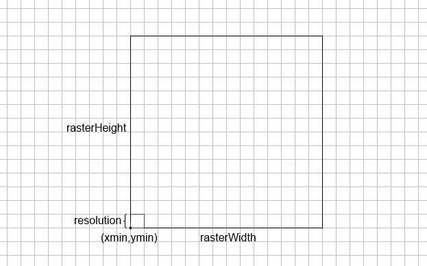
As can be seen above (xMin, yMin) specifies the lower left corner of the area that the returned raster will cover and resolution specifies the cell size. So the geographic area that will be covered by the returned raster is given by the following rectangle:
(xMin, yMin, xMin + width * resolution, yMin + height * resolution)
Limitations
The method assumes that the normal output from the Operator would be a collection of raster features that can be merged automatically. In some cases that is not true:
If some of the raster features are color rasters (RGB or RGBA) and others are numeric rasters, the method will throw an exception since it cannot merge them.
There are some operators that tag their output features in a way that inhibits automatic merging. One example is the LineOfSightOperator: different viewshed rasters may come from different observers and in many contexts it would be wrong to merge them automatically, for example when they are sent to an IsolineOperator. If you do want to use the GetRasterFeature method to retrieve a merged viewshed raster, the simplest way is to call the method from a RasterMergeOperator whose input is the LineOfSightOperator.
Example
// Get a raster of 100 x 100 pixels
public static Feature Get100x100Raster(
    RasterConversionOperator rasterConversionOperator, double xMin, double yMin)
{
    // Get a 100 x 100 pixel raster in Wgs84LongLat with a 0.01 degree cell size
    return rasterConversionOperator.GetRasterFeature(
        Crs.Wgs84LongLat, xMin, yMin, 0.01, 100, 100);
}
GetRasterFeature(Crs crs, System.Double xMin, System.Double yMin, System.Double resolution, System.Int32 width, System.Int32 height, System.Boolean upsampleBeforeMerge)
Gets raster features from the operator chain and merges them into a single raster.Syntax
public Feature GetRasterFeature (
    Crs crs,
    System.Double xMin,
    System.Double yMin,
    System.Double resolution,
    System.Int32 width,
    System.Int32 height,
    System.Boolean upsampleBeforeMerge
)
Parameters
The coordinate reference system of the result.
The x-coordinate of the lower left corner of the requested raster.
The y-coordinate of the lower left corder of the requested raster.
The geographic size of each cell in the requested raster.
The width of the returned raster in cells/pixels.
The height of the returned raster in cells/pixels.
Specifies whether to upsample low resolution rasters before merging them into the final result.
Return Value
A raster feature that covers the requested area and has the specified resolution.
Remarks
This method works in the same way as the other GetRasterFeature overload but allows the caller to specify whether low resolution rasters should be upsampled to the requested resolution before the final resulting raster is created and returned. This is usually not necessary but can give a better result if an operator chain can mix low and high resolution rasters over an area.
Platforms
Windows, Linux, Android