LineOfSightOperator.OutputMinVisibilityHeights Property
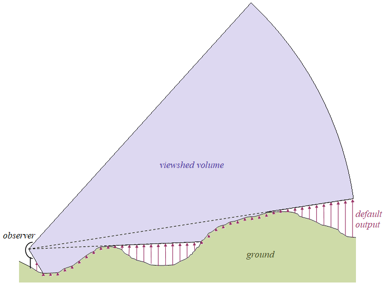
Gets or sets whether the operator shall output rasters containing in each cell the minimum height that is visible to the observer.
Syntax
public System.Boolean OutputMinVisibilityHeights { get; set; }Property Value
Default: Differs depending on type. See the table below.
Whether the operator should output minimum visibility height rasters containing in each cell the minimum height that is visible to the observer.
Default values
| Class | Default value |
|---|---|
| AirspaceCoverageOperator | true |
| LineOfSightOperator | true |
| TargetLineOfSightOperator | Not used. |
Remarks
This is the default output type of both the LineOfSightOperator and the derived class AirspaceCoverageOperator. (For the other possible output types, see OutputVolumeMesh and OutputVolumeEncodingRaster.)
 |
A minimum visibility height raster is a numeric raster where each terrain cell contains its minimal height of visibility: this is, the minimal height at which an aircraft is barely visible by the observer. These visibility heights can be heights above either sea level, ground level or treetops depending on the MinVisibilityHeightType, and they are expressed in the VerticalUnit. With the default settings, the usual visualization would display the zeros with some semitransparent color and other values invisible (a fully transparent color) since the zeros occur where the ground (or the treetops) can be seen; see also the Line of Sight Configuration Tutorial.
For a LineOfSightOperator, these output rasters will contain either 16-bit integers or Float numbers: 16-bit integers if the input elevations were integers and no CustomPropagation was used, and Float numbers if the input elevations were Float numbers or a CustomPropagation was used.
For an AirspaceCoverageOperator, these output rasters will always contain 16-bit integers.
In the output rasters, the special visibility heights undefined and positive infinity will be represented by two finite values, which depend on whether the output contains integers or floats.
The undefined value is not intended to carry any information, and it occurs only when computation is done in multiple resolution, in those cells of a low-resolution raster that are covered by high-resolution rasters. (Computation in multiple resolution is enabled via the property FirstResolutionChange (not available for an AirspaceCoverageOperator).) Concrete representation:
32 767 (the greatest signed 16-bit integer) if the output is an integer raster.
16 000 000.0 if the output is a float raster.
The positive infinity value can mean that an aircraft above the raster cell is invisible regardless of its altitude. So, this value will occur in the output rasters beyond the MaxDistance. Also, when the output is an 16-bit integer raster, the positive infinity can mean that a minimal height of visibility exists but is equal to or greater than 32 766 vertical units. Since few aircrafts can fly as high as 32 766 meters, this ambiguity is seldom important. Concrete representation:
32 766 (the second greatest signed 16-bit integer) if the output is an integer raster.
15 000 000.0 if the output is a float raster.
Most visualizations will not need to distinguish between the undefined value and the positive infinity: both should be made invisible (using a fully transparent color). The undefined value will automatically become invisible, but the color table will need a final entry that ensures that 32 766 or 15 000 000.0 is mapped to an invisible color.
These raster features will get a boolean attribute losopMinVisibilityHeights = True which can be useful for filtering.
LineOfSightOperator
When it is a LineOfSightOperator that produces these rasters, they can contain a third special value representing uncertainty; see UndefinedElevationInterpretation. And a LineOfSightOperator will give these raster features copies of all the attributes of the corresponding observer feature (except for the special geoType attribute). Also, for each observer, the first raster will be a dummy raster feature containing just a single cell that is undefined, with two boolean attributes losopMinVisibilityHeights = True and losopResolutionHint = True. The dummy raster should be harmless, and it can be useful when the rasters are sent to a RasterMergeOperator with operation = Min, since it can help the RasterMergeOperator to choose a good resolution for its merged output. See Overlapping Viewsheds.
AirspaceCoverageOperator
When these rasters are produced by an AirspaceCoverageOperator, they will always refer to the merged viewshed volume, never to its complement as other output types can do. An AirspaceCoverageOperator cannot copy attributes from observers to the rasters.
Custom propagation
Although it is not obvious from its name, this property also controls whether to output the plain 2D rasters generated by a CustomPropagation.
Platforms
Windows, Linux, Android