LineOfSightOperator.MinVisibilityHeightType Property
Gets or sets the type of visibility heights in the output (above sea-level, ground or treetops).
Syntax
public AttributeVariable< HeightType > MinVisibilityHeightType { get; set; }Property Value
Default: Differs depending on type. See the table below.
Specifies the zero level of the visibility heights in the output.
Default values
| Class | Default value |
|---|---|
| AirspaceCoverageOperator | AboveTreetops |
| LineOfSightOperator | AboveTreetops |
| TargetLineOfSightOperator | Not used. |
Remarks
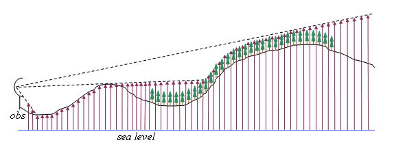
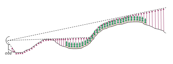
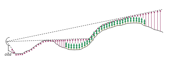
Each cell of the output raster contains a visibility height: the height where an object above the cell is barely visible; the zero level of these heights depends on the MinVisibilityHeightType.
AboveSeaLevel: the output contains visibility altitudes above the sea level (strictly speaking, above the zero level used by the rasters from ElevationInput). Use this option when the observer is looking for airplanes that fly at a constant altitude above sea level.
 |
AboveGround: the output contains visibility heights above ground. Use this option when the observer is looking for ground-based vehicles.
 |
AboveTreetops: then the output contains visibility heights above treetops. Use this option when the observer is looking for military aircraft that fly as low as possible to avoid radar. (In the picture, the arrows start from the treetops level, although they may appear to start from the ground in a foggy forest.)
 |
This property can be given a static value, but since it is an attribute variable, its value can also depend on an attribute of the observer. But other attribute variables of LineOfSightOperator represent physical properties of the observer, whereas MinVisibilityHeightType represent the intended use of the observer: does it look for ground-based vehicles, or aircrafts near the ground, or aircrafts on cruising altitude? Other attribute variables may affect the size and shape of the output viewshed, but the MinVisibilityHeightType affects the very meaning of the cell values of the output. Therefore, if observers with different output height types are mixed in a map presentation, then their viewsheds ought to be displayed by different visualizers, so that their meanings are not confused. This is easy enough. If the MinVisibilityHeightType depends on an observer attribute, say TARGETTYPE, then the TARGETTYPE is also attached to the output rasters from the LineOfSightOperator, so each visualizer can use a condition that checks for an appropriate TARGETTYPE.
Platforms
Windows, Linux, Android