LineOfSightOperator: What can I see?
The LineOfSightOperator can be used to display a viewshed surface or a viewshed volume.
Displaying a viewshed surface
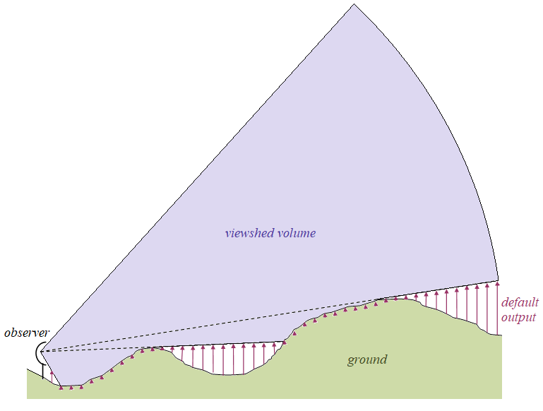
The default behavior of a LineOfSightOperator can be illustrated in a vertical profile:
 |
The default output is a raster where each cell contains the vertical distance from the ground up to the bottom of the viewshed volume, indicated by the arrows.
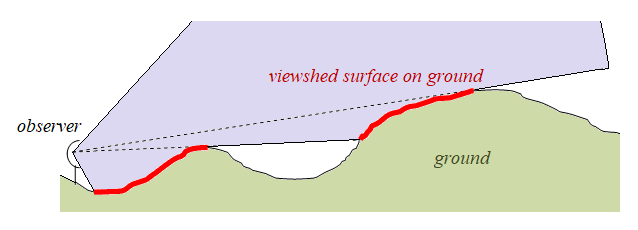
If this raster is displayed in a 2D map with a RasterVisualizer that displays zero as red and other values as transparent, the red area will represent the viewshed surface on the ground:
 |
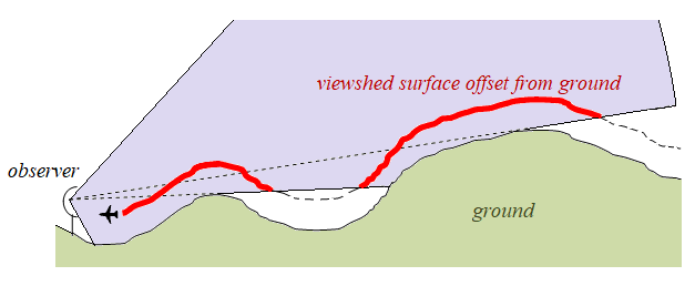
But there are other ways to use this raster. If we instead display all raster values up to 50 as red, the red area will represent what is visible of a surface that is offset 50 meters from the ground. This corresponds to a use case where the observer is looking for low-flying aircrafts that are assumed to fly 50 meters above ground.
 |
Since you may not know exactly how low the aircrafts will fly, you can display three alternative layers that use different assumptions, for example 50, 100 and 150 meters. Or you can make a three-color visualization with one color for the interval 0 to 50 m, another for the interval 51 to 100, and a third for the interval 101 to 150 m.
The heights to the viewshed bottom do not have to be measured from the ground. There are three options, controlled via the LineOfSightOperator.MinVisibilityHeightType property:
above ground,
above treetops,
above sea level.
The two first options are identical if trees are not modelled in your configuration. If trees are modelled (see Trees as Obstacles), the correct choice when looking for low-flying aircrafts is above treetops, since the treetops will be the worst danger for the aircrafts. On the other hand, if an observer is looking for terrain trucks, the correct choice is above ground, since trucks do not climb trees: the roofs of the trucks will have a constant height above the ground. The last option, above sea level, can be useful when the observer is looking for aircrafts that are cruising at a constant altitude above sea level. But note that a cruising aircraft could be too high for the observer, and the default type of output raster cannot be used to determine where that happens, since it gives no information about the top of the viewshed volume. So other types of output are needed for that.
Displaying a viewshed volume
The simplest way to display the whole viewshed volume is to set LineOfSightOperator.OutputVolumeMesh = True, and use a MeshVisualizer in a GlobeView.
But a mesh visualization of a complicated volume is sometimes difficult to understand fully. So the LineOfSightOperator can also send volume information to an IsolineOperator that can generate horizontal slices through the volume, or to a VerticalProfileOperator that can generate a vertical slice.
The horizontal slices can be displayed as lines or polygons in a globe view to enhance the mesh visualization, or they can be displayed in a plain 2D map (this is the only way to display viewshed volume information in a 2D map).
The vertical slice is normally displayed in a separate vertical profile view. It is also possible to display it in a globe view to enhance the mesh visualization, but that will require a custom operator and some application logic.
Unfortunately, a mesh geometry would be impractical for slice calculations. To generate slices, you must set LineOfSightOperator.OutputVolumeEncodingRaster = True, which will produce a set of raster features that represent the viewshed volume in a special, undocumented way. Only three other operators can understand this kind of volume-encoding rasters: the IsolineOperator, VerticalProfileOperator and the AirRouteOperator.
Tutorial
To get some hands-on experience of line of sight, you can go to the Line of Sight Configuration Tutorial.
Up: Visibility Analysis
Next: AirspaceCoverageOperator: What can we see together?