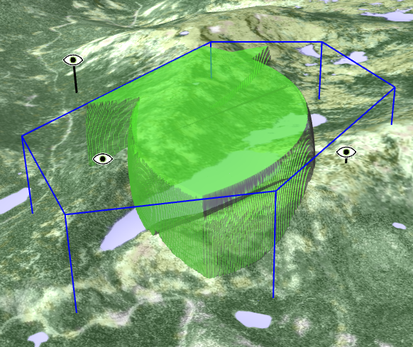
AirspaceCoverageOperator: What can we see together?
The AirspaceCoverageOperator class is derived from the LineOfSightOperator class and is rather similar; its purpose is to combine the viewsheds of several observers into one viewshed. The combined viewshed can then be output in the same formats that are available in the LineOfSightOperator. There is a sample configuration airspace_coverage.px that you can try out in Carmenta Explorer.
The default viewshed combination is simply the union of all individual viewsheds, so you can use the default setting when it is enough that one observer can see something. But sometimes we need more than one observer. For example, we may use a set of radio beacons of type DME as observers. (To be pedantic, a beacon does not observe aircrafts: it is the other way around, but it does not matter since a free line of sight can be used in either direction.) When an aircraft detects a DME beacon signal, it can figure out the distance to the beacon but not the direction, and therefore the aircraft navigator needs free lines of sight to at least three beacons. To indicate that at least three observers are needed, you set AirspaceCoverageOperator.MinObservers = 3. In mathematics, this kind of set combination does not have a snappy name, but it can be described as the union of all triplewise intersections of the viewsheds (or n-wise in the general case).
 |
The operator can also understand that observers can be of different types that have different requirements. See AirspaceCoverageOperator.ObserverTypeAttribute and AirspaceCoverageOperator.ObserverTypeConditions.
The operator can optionally take an area of interest in the form of a polygon. The polygon is extruded to a volume between a top and a bottom altitude. Then, the operator can be configured to output not the combined viewshed, but the complement of the combined viewshed with respect to the volume of interest. This is useful when you want to see whether your combined viewshed fully covers the volume of interest, or if there are any small parts left. When an area of interest has been given, the operator can also output a coverage raster suitable for display in a 2D map: each raster cell contains the covered proportion of the volume of interest directly above the raster cell.
Previous: LineOfSightOperator: What can I see?
Up: Visibility Analysis
Next: TargetLineOfSightOperator: which targets can I see?