Terrain Analysis Extension
Efficient utilization of terrain and obstacle data sources is a key feature in a lot of aeronautical applications. Implementation of these functionalities has been streamlined in the VerticalProfileOperator, VerticalClearanceOperator and TerrainWarningOverlay for Carmenta Engine, saving you valuable development time.
Terrain and obstacle data can be accessed in real time via Carmenta Engine's core functionality, using any of the 70 geospatial data formats that Carmenta Engine supports, including common military formats like Digital Terrain Elevation Data (DTED). In addition, outputs from other Carmenta Engine analyses, such as the line-of-sight functionality, can be used as a terrain analysis input, to answer questions like, "does the route intersect the line of sight of any threats?"
VerticalProfileOperator
The VerticalProfileOperator generates a vertical profile of a corridor along a route, cutting through both raster and vector data sources. The resulting profile view constitutes a separate Carmenta Engine map, making it easy to apply the same visualization to the profile as the 2D and 3D maps.
|
|
VerticalClearanceOperator
The VerticalClearanceOperator complements the vertical profile functionality by calculating the terrain and obstacle clearances of a corridor along a route. The result of the clearance calculation can be visualized as overlays in a 2D map, e.g. to provide decision support during mission planning.
|
|
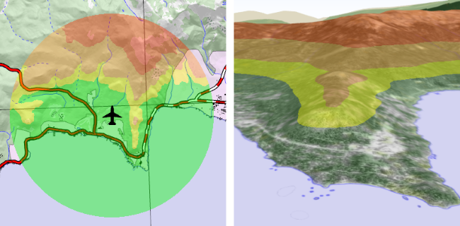
TerrainWarningOverlay
The TerrainWarningOverlay enables you to apply a color-coded terrain awareness visualization to both 2D and 3D views. This configurable color-coding functionality is dynamically updated as the aircraft position and altitude changes.
 |
See Also
Reference
VerticalProfileOperator
VerticalClearanceOperator
TerrainWarningOperator
TerrainWarningOverlay