LineOfSightOperator.InterpolatedCells Property
Gets or sets a value, telling how far away from the observer elevations should be interpolated.
Syntax
public AttributeVariable< System.Int64 > InterpolatedCells { get; set; }Property Value
Default: 15
A number of elevation raster cells, telling how far away elevations should be interpolated.
Remarks
Preamble: this property is fully available only from the LineOfSightOperator and its derived type AirspaceCoverageOperator. The derived type TargetLineOfSightOperator can only use the default value, so the property is hidden in Carmenta Studio and an attempt to modify it via the API will throw an exception saying the property is read-only for TargetLineOfSightOperator. The related VisibilityIndexOperator also uses the default value only, and its API lacks the property completely.
When a ray from the observer is traced through the elevation raster, it will usually go between the centers of the elevation raster cells. Interpolation will be more accurate than nearest-neighbor lookup, but also slower. However, the cost of interpolating a single lookup does not depend on the distance from the observer, whereas the accuracy improvement is usually greater near the observer. So it usually makes sense to interpolate only near the observer.
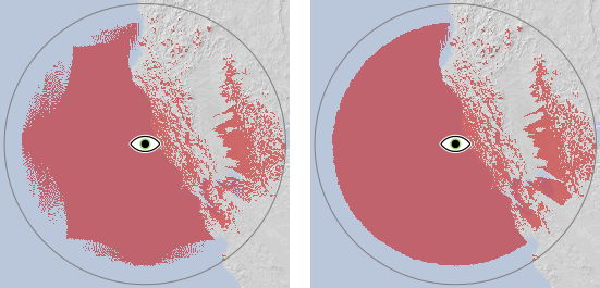
The value of this property gives the maximal distance from the observer that interpolation will be used, measured as a number of elevation raster cells of the resolution used nearest the observer. The default value is often a sweet spot: using a lower value can cause visual artifacts while not gaining much speed, while a larger value will be slower and may not improve accuracy noticeably. However, if the MaxDistance is long, the elevation resolution is coarse, and the viewshed is bounded by a horizon over water or flat ground, a moiré pattern can appear near the boundary unless InterpolatedCells is increased:
 |
It is not obvious why it helps to interpolate in the ocean which has constant elevation, but it has to do with the operator doing a preprocessing step to model the earth curvature.
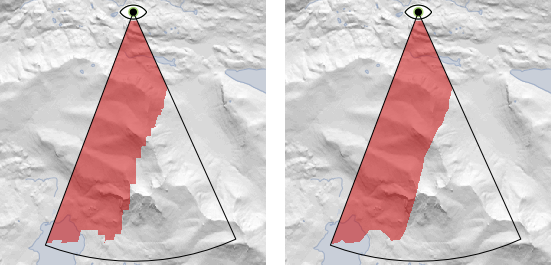
Over land, the inaccuracies caused by nearest-neighbor lookup are usually masked by irregularites in the elevations, but one can sometimes see a jagged viewshed boundary that would be smoother with an higher value for InterpolatedCells:
 |
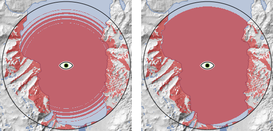
With integer elevations in high resolution and an observer at a low altitude, one can sometimes see multiple rings where the viewshed boundary should be. Although the rings look somewhat similar to the moiré pattern, they have a different cause and interpolation does not help. Instead, it will help to convert the elevations to Float via a RasterConversionOperator before they arrive to the LineOfSightOperator.
 |
Platforms
Windows, Linux, Android