Working with DTED Data
The DTED format for elevations has some peculiarities, which requires care when using Carmenta Engine. Your basic choice is whether you should let the DtedDataSet read the native data directly or if you should use DtedDataSet.RasterCachePolicy to cache the data for faster access, but there are other things to consider as well.
First, let us review the format itself.
The design of DTED elevation data
DTED, Digital Terrain Elevation Data, is a U.S. format for elevations. The elevations are raster data, which are stored in Wgs84LongLat, and distributed in several files, each one covering one degree square, and containing an array of raster pixels. Each raster pixel contains the ground elevation in meters above mean sea level, stored as an integer.
(Normally, Carmenta would use the term "raster cell" for a raster pixel, but this usage would conflict with the DTED specification, which uses "DTED cell" for a one degree file.)
DTED comes in different resolutions, known as levels. The levels that have been standardized are Level 0, 1 and 2.
In Level 0, the raster pixels are about 900 meters.
In Level 1, they are about 90 meters.
In Level 2, they are about 30 meters.
(Three more levels, 3, 4 and 5, with higher resolution have been proposed, but not yet standardized.)
Actually, since DTED is stored in Wgs84LongLat, the sizes of raster pixels are not specified in meters but in arc seconds. And the conversion between arc seconds and meters is different for latitude and longitude:
One arc second of latitude is fairly constant, varying from 30.72 meters near the equator to 31.03 meters near a pole (due to the flattening of the Earth).
One arc second of longitude is 30.92 meters on the equator, but near Stockholm it is only half as long, being about 30.92 * cos(lat) in general (since the meridians converge towards the poles).
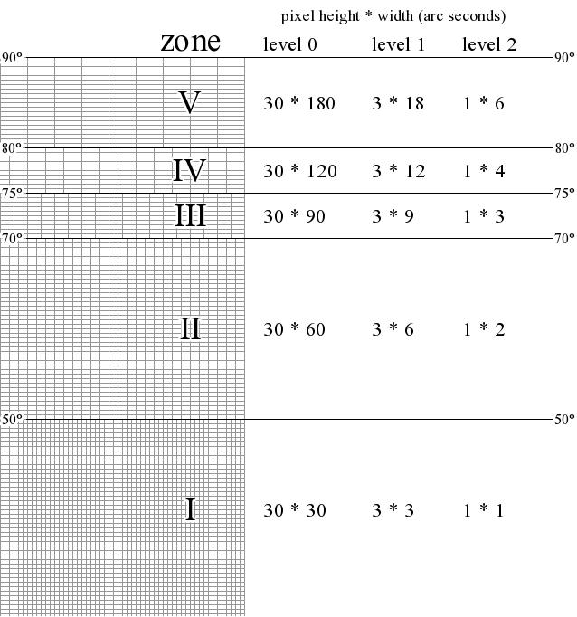
This caused a problem for the DTED designers: If they had insisted that each DTED level should have a constant pixel size in arc seconds, then their pixels would be too narrow at high latitudes, as expressed in meters. The problem was solved by introducing five latitude bands for DTED, where the pixel width in arc seconds is larger for latitude bands near a pole.
Below is a schematic diagram of the design:
 |
Reading DTED data directly using DtedDataSet
In Carmenta Engine, the simplest way to read DTED data is by a DtedDataSet (the general GdalDataSet could also be used, but we do not recommended it for DTED). Since DTED contains only pure data, you need to add a visualization in some way, as described in the general Working with Raster Data; a ShadeOperator is a common choice.
 |
Using different DTED Levels
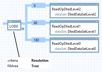
As always, it is important to read the appropriate data resolution for the view scale. If you use DTED directly, you do not have many resolutions to choose from, but at least you can use a LevelOfDetailOperator that chooses between Level 0, Level 1 and Level 2 depending on view scale (or view resolution). If your most detailed DTED levels do not have complete coverage, you can use LevelOfDetailOperator.FillArea = True, since the gaps will then be filled with DTED data of lower resolution.
 |
When the LevelOfDetailOperator.Criteria is Resolution, the resolution limits are in meters. The settings above mean:
at the highest view resolutions, use Level 2 (one data pixel is about 30 m);
if a view pixel is between 60 m and 180 m, use Level 1 (one data pixel is about 90 m);
if a view pixel is larger than 180 m, use Level 0 (one data pixel is about 900 m).
These limits can be modified a little, but it is unwise to use data pixels whose size is less than half of the view pixel size. (That is, linear size. So it is okay if the area of a data pixel is about 1/4 of a view pixel, but not much smaller.) Note that this is true for Level 0, too: a view pixel should not cover more than about 1800 * 1800 meters when Level 0 is used directly. So the configuration above should be safeguarded; the simplest way is to set a Layer.MaxScale.
If a view pixel displays d meters of the world, then the view scale is about 1 : d*3780, assuming a view resolution of 96 dots per inch.
So, our Layer.MaxScale should be about 1800 * 3780 = 6 804 000.
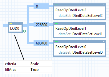
If you prefer to let LevelOfDetailOperator.Criteria be Scale, then the limits are for the (inverted) view scale. To get the same behavior as before, multiply the resolution limits by 3780 to get the (inverted) scale limits:
 |
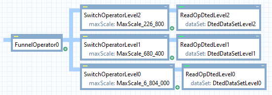
A simpler alternative to the LevelOfDetailOperator is to use a FunnelOperator connected to a list of SwitchOperator instances.
 |
This simple alternative will not work in all situations, since the funnel operator will not merge overlapping rasters that come from different resolution levels. For example, if all you do with the data is to assign a color to each elevation interval (hypsometric colors), then the coarsest DTED rasters, which will come last from the funnel operator, will be painted over the finest rasters and hide them. This could be fixed by reversing the order of the three parallel operator chains above, but only if the display colors are opaque: if they have some transparency, all different resolutions will be visible to some extent, which will not look good.
But although a funnel operator will not merge overlapping rasters, most operators that do some kind of raster analysis or processing will start by merging all their input rasters into a single raster. They do this because they must: even if their raster input would arrive in a single resolution, the data is usually retrieved in separate tiles from the dataset, so their raster input is merged to avoid visible artefacts at tile edges. This mechanism also handles overlaps by using the highest resolution in the overlap. So, the funnel operator above would work if the result is sent to a ShadeOperator, for example. (This is useful to know, not so much for DTED data, but for other kinds of raster data that do not work well with fillArea = True in a level-of-detail operator. This can happen if different levels of detail are stored in different Coordinate Reference Systems, or if some raster data contains areas with the undefined raster value or the transparent color.)
Using DtedDataSet.RasterCachePolicy
In many applications, it is a drawback that there are only three levels of DTED: the resolution differs too much between Level 0 and Level 1, and there is nothing coarser than Level 0. To improve matters, you can often set DtedDataSet.RasterCachePolicy to Overviews. This will make the dataset create lower-resolution overviews of the DTED data, so that you can get a great number of resolutions.
Literature
The specification of the format:
NIMA. Performance Specification: Digital Terrain Elevation Data (DTED), MIL-PRF-89020B, 23 May 2000.
The quality of DTED data varies. The usual sources of DTED Level 1 data are known to contain artifacts that can appear as striped patterns in some visualizations. With Carmenta Engine, the ShadeOperator usually does not show stripes, but the ShadowOperator can do it. These artifacts are discussed on the following site:
NOAA National Geophysical Data Center. DTED Level 1 Source Characteristics.