LevelOfDetailOperator.FillArea Property
Gets or sets a value that determines whether gaps in detailed data shall be filled by coarser data.
Syntax
public System.Boolean FillArea { get; set; }Property Value
Default: false
True to fill gaps with coarser data; otherwise, False.
Remarks
If FillArea is False, the LevelOfDetailOperator will retrieve data from at most one of its inputs, determined by the View scale or resolution. (The Criteria controls whether scale or resolution is used.)
If FillArea is True, the LevelOfDetailOperator will try to fill the entire View.Area with data, using coarser data if necessary. It will first request data from the input that it would ordinarily use, according to view scale or resolution. If data from this input does not cover the entire View.Area, the LevelOfDetailOperator will go on and request data from the next input. This will continue until the LevelOfDetailOperator runs out of inputs or the entire View.Area has been filled with data.
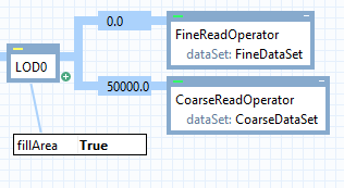
For example, in this configuration, the LevelOfDetailOperator can behave in two ways, depending on the view scale.
 |
If the scale is more detailed than 1 : 50 000, then all available data from the fine dataset is retrieved within the view area. If the fine data does not fill the entire view area, data from the coarse dataset is also retrieved.
If the scale is less detailed than 1 : 50 000, then the fine dataset is ignored, and only the coarse one is used.
In a detailed scale, the LevelOfDetailOperator must avoid producing fine and coarse data that overlap, because the visualization may not be completely opaque and contiguous, so the operator cannot assume that the display of the fine data would completely hide any overlapping coarse data. Therefore, the operator clips away coarse data where it overlaps the data extent polygons for the fine dataset. Note that this fine data extent may differ from the extent of the actual fine dataset features: the data extent is a kind of metadata that the LevelOfDetailOperator can ask the dataset to report.
Limitations of FillArea
Setting FillArea = True works well only if the datasets report their data extent polygons with enough accuracy. Unfortunately, many kinds of dataset may report an overestimate of their true data extent, because they always report one or more rectangular polygons as the data extent. Currently, only S57DataSet and RaveGeoDataSet can report their data extent as polygons of arbitrary shape. Another cause of overestimation is raster data that contains areas with the undefined value or a fully transparent color, since those areas would be included in the reported data extent despite their lack of data.
Alternatives to FillArea
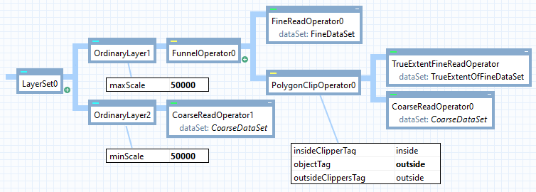
When a dataset overestimates its own data extent so that FillArea = True cannot be used, there is alternative solution, if you can construct an auxiliary dataset containing the true extent polygons of the first dataset. These polygons can be used as a PolygonClipOperator.ClipperInput, where the PolygonClipOperator.ObjectInput would be the features from a less detailed dataset that should be used only outside the extent polygons.
So to continue our example: If our fine dataset turns out to exaggerate its data extent, but we succeed in constructing an auxiliary dataset whose features give the true extent as polygons, then an alternative configuration could look something like this:
 |
The drawback of this alternative is that it could be difficult to construct the auxiliary dataset. Also, if there were more levels of detail than just two, this alternative configuration would become complicated.
Platforms
Windows, Linux, Android