Crs.ParseMgrsAsArea Method
ParseMgrsAsArea(GeodeticDatum geodeticDatum, MgrsLetteringScheme letteringScheme, System.String mgrs)
Parses an MGRS reference into a LongLat polygon geometry.Syntax
public static PolygonGeometry ParseMgrsAsArea (
    GeodeticDatum geodeticDatum,
    MgrsLetteringScheme letteringScheme,
    System.String mgrs
)
Parameters
The geodetic datum used, for both input and output.
The MGRS lettering scheme used: new or old. The old one may be used only if the datum ellipsoid is Bessel 1841, Bessel Namibia, Clarke 1866, Clarke 1880 or Clarke 1880 (IGN).
The MGRS reference.
Return Value
A LongLat polygon geometry that covers the area that the MGRS reference denotes.
Remarks
If the MGRS reference cannot be parsed, the method will throw an exception, whose message explains why the parsing failed.
For more details about the MGRS syntax, see the similar method ParseMgrs.
The difference between the methods is that ParseMgrs returns a point representing the center of the area, while ParseMgrsAsArea returns a polygon geometry that represents the entire area. The polygon corner coordinates will be expressed in LongLat in the GeodeticDatum that is given as a parameter. The first point of the polygon outline will be the southwest corner, with the rest of the corners following in counterclockwise direction. The polygon outline will have four points, except when the MGRS string is just a single character A, B, Y or Z that denotes a polar area that is 180° wide: then the outline gets two extra points to avoid ambiguity about inside/outside.
Since the returned polygon is expressed in LongLat (with the specified geodetic datum), you will usually not care about what UTM/UPS projection zone is used by the MGRS string. But if you do want to know the projection zone, it is not hard to figure out from the MGRS string:
If the first character is A or B, the projection is UPS for the south pole (south polar stereographic).
If the first character is Y or Z, the projection is UPS for the north pole (north polar stereographic).
If the string starts with one or two digits followed by a letter, then the digits give the UTM zone number, while the letter gives the latitude band. If the letter is N or later in the alphabet, then the UTM projection is for the north hemisphere, otherwise for the south hemisphere (see UtmHemisphere).
Extended UTM Zones
According to the UTM specifications, a UTM grid for one zone may be extended a bit outside its standard zone boundaries. But in each zone, the MGRS lettering scheme uses only eight column letters for the 100-km squares, so if MGRS notation shall be used, the UTM grid cannot be continued farther than 400 km from its central meridian. The ParseMgrsAsArea method accepts MGRS references also in the extended zone.
 |
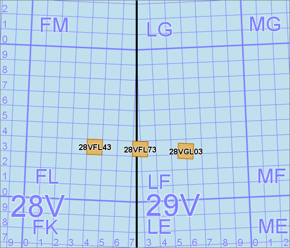
The image above shows the boundary between UTM zones 28 and 29 inside latitude band V, and we see that the 100 km square 28VFL is not completely inside the standard zone 28. We also see three example results from ParseMgrsAsArea:
The MGRS reference 28VFL43 denotes a 10 km square that is completely inside zone 28, and the parsing method would return the leftmost orange polygon.
The MGRS reference 28VFL73 denotes a 10 km square that is partially outside the standard zone 28, and the parsing method would return the middle orange polygon.
The MGRS reference 28VGL03 denotes a 10 km square that is completely outside the standard zone 28, and the parsing method would return the rightmost orange polygon.
Note that in the last example, there is nothing of the surrounding 100 km square 28VGL that is inside the standard zone 28, so the background grid (created by UtmGridGenerator) does not show a GL label here. Within latitude band V, 56°N to 64°N, the standard zone 28 uses only the column letters C, D, E and F, but ParseMgrsAsArea handles the extended zone 28, for which it accepts any column letter in the range A to H.
Platforms
Windows, Linux, Android
See Also
Reference
Crs Class
Core Module
ParseMgrs
TryParseMgrs
FormatMgrs
FormatUtmUps
UtmGridGenerator