ProjectionPurpose Enumeration
Specifies the purpose of a map projection instance.
NuGet/Assembly: Carmenta.Engine.5.17.0.nupkg (in the CECore assembly)
Syntax
public enum ProjectionPurposeValues
| Value name | Value | Description |
|---|---|---|
| Storage | 0 | Indicates that the projection is used in a DataSet. The projection will do nothing special when projecting lines and polygons. They are normally projected point by point; extra points may be inserted along edges, but normally only for polygons that have been clipped (see ProjectParameters). |
| Presentation | 1 | Indicates that the projection is used in View. If the projection is azimuthal, it will adjust projected lines and polygons that are near the antipode of the projection center. |
Remarks
There are two reason why an azimuthal projection, when used in a View, needs special adjustments near the antipode.
One reason is that a short edge near the antipode may have its end points projected to opposite sides of the projection center, so the (projected) straight line between them can cross the central parts of the map. To avoid this, such a projected edge will get extra points along an Archimedes spiral between its end points.
Another reason is that a small polygon that surrounds the antipode will be projected to a polygon that surrounds most of the map: if its interior is colored, the color will be displayed everywhere, except where it should be. To avoid this, such a projected polygon will be turned inside-out: the projected perimeter will become a hole, and a new perimeter will follow the boundary circle of the projection.
 |
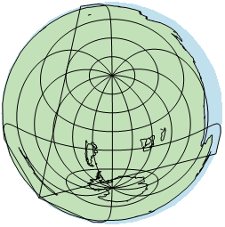
The map above shows a View with an AzimuthalEquidistantProjection, whose purpose is Storage. The Australia polygon is inside-out, and when it is filled with green color, it hides all countries, except some that happened to be drawn after Australia. The blue background appears where the interior of Australia should really be. We also see that some lines in the graticule take dangerous shortcuts.
 |
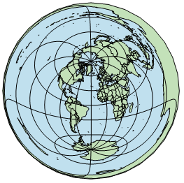
In this map, the purpose has been changed to Presentation. Australia is now projected to a polygon whose perimeter follows the boundary circle, and the Australian coastline is a hole is this circle. The lines in the graticule no longer take dangerous shortcuts.
Platforms
Windows, Linux, Android