AzimuthalEquidistantProjection Class
The Azimuthal Equidistant Projection.
NuGet/Assembly: Carmenta.Engine.5.17.0.nupkg (in the CECore assembly)
Syntax
public class AzimuthalEquidistantProjection : ProjectionRemarks
The azimuthal equidistant map projection is azimuthal, but it is conformal only at the projection center.
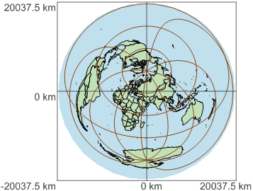
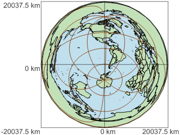
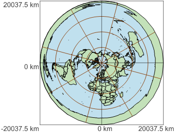
The projection is continuous everywhere except at the antipode of the projection center. The antipode is projected to a boundary circle. Although the whole world can be shown, the region within 3000 km (about 30 degrees) from the antipode is quite distorted.
The projection is equidistant: the distance from an arbitrary projected point to the projection center is true to scale.
You can choose the Earth shape you want (sphere or ellipsoid) via the Shape argument.
Using degrees for projected coordinates
The projected coordinates are expressed in the specified LengthUnit. But if you want to implement the polar zones of the ARC Standard Raster Product Specification (ASRP), you need projected coordinates in degrees, which is an angular unit.
Since Carmenta does not support using an AngleUnit for an AzimuthalEquidistantProjection, you have to emulate the degree as an ordinary LengthUnit. To implement the polar zones of ASRP, the simplest way is to construct a Crs using Wgs84 as datum, and an AzimuthalEquidistantProjection with default values for properties, except that the CentralLatitude should be 90° or -90°, and the LengthUnit should be user-defined and equal to 111319.491 m, (which is 1/360 of the Wgs84 equator).
Seamless editing of global geodata
If you need to handle Feature objects all over the world, it can be a good idea to store them in this projection, to ensure that no feature crosses an interruption in the projection. The common design - to store the features in LongLat - can cause problems across the date line: the StandardTool should be able to edit a LongLat feature that crosses the date line, but some operators would be confused by the interrupted longitude range.
So, for a DataSet with global coverage, an Azimuthal Equidistant projection is usually a more robust choice than LongLat, but it would be less efficient if there is a lot of features near the antipode of the projection center. The inefficiency has two reasons:
If the view has to show a region containing the antipode, then the dataset must return all its geodata. (When the View.Area is reprojected into a query rectangle, it will cover the whole world.)
Even if you never look at the antipode region, the dataset must, at each update of the view, return each feature that (in real life) surrounds the antipode. (This is because the projected bounds of such a feature would cover the whole world.)
But for most applications, you can find some small region that has few editable features. Some examples:
If all editable features are on land, then there is a point in the South Pacific around 125.5°W, 48.5°S, that is 2670 km from the nearest land or island. So, your azimuthal equidistant projection should have centralLongitude: 54.5 and centralLatitude: 48.5.
 |
If all editable features are at sea, then there is a point in west China at 86.7°E, 46.3°N, that is 2650 km from the nearest sea. So, your azimuthal equidistant projection should have centralLongitude: -93.3 and centralLatitude: -46.3.
 |
Commercial airlines usually do not fly across Antarctica. So, to store editable aeronautical features, your azimuthal equidistant projection could have centralLongitude: 15 and centralLatitude: 90.
 |
But if you really need to edit many features all over the world, then an efficient implementation may require two or more datasets with different projections.
Inheritance Hierarchy
System.Object
EngineObject
ResourceObject
Projection
AzimuthalEquidistantProjection
Platforms
Windows, Linux, Android
AzimuthalEquidistantProjection Members
The AzimuthalEquidistantProjection type has the following members.
Constructors
| Name | Description |
|---|---|
| AzimuthalEquidistantProjection | Initializes a new instance of the AzimuthalEquidistantProjection class. |
Properties
| Name | Description |
|---|---|
| Authority | Gets the name of an authority, which is often "epsg". Inherited from Projection |
| AuthorityCode | Gets the unique code for the projection instance, according to the Authority, for example "19883". Inherited from Projection |
| CentralLatitude | Gets the central latitude, also known as latitude of origin. |
| CentralLongitude | Gets the central longitude, also known as central meridian or longitude of origin. |
| FalseEasting | Gets the offset added to the projected x coordinates (the eastings). |
| FalseNorthing | Gets the offset added to the projected y coordinates (the northings). |
| IsDisposed | Gets a value that tells whether the current AzimuthalEquidistantProjection has been disposed. Inherited from EngineObject |
| LengthUnit | Gets the length unit of the projected coordinates. |
| Gets a pre-defined LongLatProjection instance. Inherited from Projection | |
| Name | Gets or sets the name of the AzimuthalEquidistantProjection. Inherited from ResourceObject |
| NativeHandle | Gets the native Carmenta Engine kernel object the current AzimuthalEquidistantProjection represents. Inherited from EngineObject |
| Purpose | Gets a value that tells whether the projection instance is intended for data storage or for presentation. |
| Shape | Gets a value that tells whether the Earth is represented as a sphere or as an ellipsoid. |
| SphereRadius | Gets an explicitly specified sphere radius. |
| SphereRadiusSource | Gets a value that tells how the sphere radius is determined. |
| IUserProperties.UserProperties | Gets the AttributeSet that contains the user properties. Inherited from IUserProperties |
Methods
| Name | Description |
|---|---|
| Clone | Creates a copy of an object. Inherited from EngineObject |
| Dispose | Releases the reference to the native Carmenta Engine kernel instance the EngineObject represents. Inherited from EngineObject |
| Equals | Determines whether this instance is equal to another. Inherited from EngineObject |
| Returns one of the 120 predefined instances of Universal Transverse Mercator. Inherited from Projection |