GridGenerator.Bounds Property
Gets or sets the bounding rectangle of the grid lines.
Syntax
public Rectangle Bounds { get; set; }Property Value
Default: Rectangle.Infinite
The bounding rectangle of the grid lines, expressed in same Coordinate Reference System as the grid.
Remarks
The generated grid lines can be constrained to a given Bounds rectangle, for example the area of use for a national grid. A bounded grid will usually look best if the bounds rectangle is aligned with the grid lines. If the bounds rectangle is not aligned, the generated grid lines will end strictly at the boundary, but if there are also rectangular polygons generated via Rectangles, they will all have the same size with some partially outside the bounds.
Default behavior
With the default Bounds, the grid will usually be constrained only by the bounding rectangle of the Coordinate Reference System of the grid; that is, the bounding rectangle of the world map according to this CRS. Some types of map projections will cause tighter default constraints, though:
An azimuthal map projection has a circular world map, and the effective bounds will be a square inscribed in the circle.
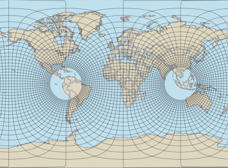
With a TransverseMercatorProjection, a grid will by default be constrained to go at most 9 500 nominal Transverse Mercator kilometers from the central meridian or the antimeridian, corresponding to about 64.5 degrees of arc distance.
 |
The image shows a GridGenerator with the default Bounds that has generated the Swedish SWEREF99TM grid, which is based on a Transverse Mercator projection with central meridian at 15°E. The default bounds are obviously too generous compared to the extent of Sweden, but at least they make the grid stop at a safe distance from the projection's west pole in Colombia and and east pole in Indonesia. (The View uses a Miller cylindrical projection.)
Finding a sensible definition of the bounds
If you only have one or a few Coordinate Reference Systems to generate grids for, you can figure out sensible bounds manually. On the other hand, your application may be intended to be more automatic, letting a user select an arbitrary CRS and getting a grid with sensible bounds directly. For this purpose, you could use the static method Crs.AuthoritativeAreaOfUseBounds if the user-selected CRS has an EPSG code. But note that this method returns a rectangle expressed in WGS84 LongLat, so it must be reprojected to the user-selected CRS before you can use it as the Bounds.
Platforms
Windows, Linux, Android