Crs.EtrsLcc Property
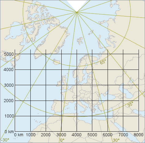
Gets a predefined Crs for Europe, based on a Lambert Conformal Conic projection.
Syntax
public static Crs EtrsLcc { get; }Property Value
A Crs representing ETRS89-extended / LCC Europe, which is recommended for pan-European conformal mapping.
Remarks
The Carmenta name is derived from the original name ETRS - LCC, but the terminology has changed over the years. EPSG lists the following alternative names:
Name | Comment |
|---|---|
ETRS89-extended / LCC Europe | The name preferred by EPSG (since 2019) |
ETRS - LCC | EuroGeographics Identifier, superseded by the INSPIRE identifier |
ETRS89-LCC | EU INSPIRE identifier |
ETRS89 / LCC | EPSG abbreviation |
ETRS89 / LCC Europe | EPSG alias |
The EPSG code is 3034.
The geodetic datum is officially ETRS89, which coincided with WGS84 on January 1, 1989, but which is attached to the Eurasian tectonic plate, so it has diverged from WGS84 by 2 - 3 cm / year since then due to continental drift. However, Carmenta Engine regards the ETRS89 of this CRS to be the same as WGS84.
The "extended" in the EPSG name refers to the unusual fact that the area of use for the projected CRS is larger than the area of use for the geodetic datum; for example, the CRS can be used for Iceland, Turkey and the Canary Islands even though the geodetic datum is not defined there. That makes sense because the CRS is intended for map scales that are not very detailed, so the difference between ETRS89 and WGS84 can be ignored.
The map projection is a LambertConformalConicProjection with two standard parallels at 35° N and 65° N, central latitude at 52° N, central longitude at 10° E, a false easting of 4 000 000 m, and a false northing of 2 800 000 m.
 |
Platforms
Windows, Linux, Android