Classes for Coordinate Reference Systems
A coordinate system for maps is technically known as a Coordinate Reference System or a CRS. The corresponding Carmenta Engine class is the Crs class, which is the central class for coordinate handling. Each View must have a Crs that tells how the map shall appear on the screen. Each DataSet must also have a Crs, which is normally attached to all features produced by the dataset; in some data formats, though, each individual feature may be expressed in a CRS that differs from the main CRS of the dataset.
The Crs class also provides many useful methods for coordinate handling and computations, but you can normally let Carmenta Engine convert automatically from dataset feature Crs to view Crs; see the section When are things reprojected?.
This page describes how a Crs instance is made up of smaller parts. If the structure looks complicated, note that there are many shortcuts you can use to construct a Crs instance; see the Crs class for details.
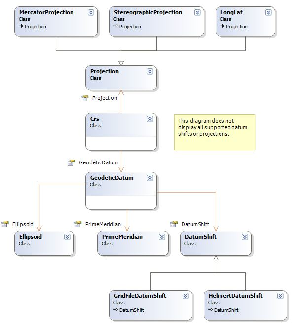
Basically, a Crs instance consists of a GeodeticDatum that tells how positions on Earth are assigned latitude and longitude, and Projection that tells how latitude and longitude are converted to plane Cartesian coordinates (easting and northing).
 |
Geodetic Datums
As we learned in a previous chapter, the latitude/longitude graticule defined by WGS84 is not the only one. For historical reasons, there are many older graticules in use, some global ones (like the Russian PZ-90), some continental ones (like NAD27 and ED50), and hundreds of national ones. Instead of graticule, you will usually see the term geodetic datum in this context; the Carmenta Engine class is GeodeticDatum.
Since different geodetic datums often disagree by hundreds of meters, it is important not to confuse them.
A geodetic datum needs a reference ellipsoid that gives the size and shape of the Earth model used. The Carmenta class is the Ellipsoid. Surveyors do not like ellipsoids that are spherical, but map makers sometimes use spheres for map projections (see next section).
The meridian that has zero longitude in a geodetic datum is known as the prime meridian, see PrimeMeridian. This meridian is not necessarily Greenwich.
We often need to transform longitude and latitude from one geodetic datum to another. A method to do so, often called a datum shift, is by its nature approximative and empirical. Carmenta Engine has the abstract base class DatumShift.
In some models of CRS classes, one can define a geodetic datum without attaching a datum shift to it, and then select and use a suitable datum shift later, when the target datum is known. But in Carmenta Engine, a new GeodeticDatum instance must get a datum shift already at construction; the datum shift must specify a transformation to or from another geodetic datum instance that is already known, usually WGS84. Technically, Carmenta Engine is based on early binding and a hub transformation technique where WGS84 is the hub. (When very high transformation accuracy is required, it should be possible and beneficial to write a Carmenta Engine application that emulates the alternative, late binding, although that would be going somewhat against the grain of Carmenta Engine. See the last section of Letting a DataSet read its CRS from data files)
To summarize, a GeodeticDatum is made up of an Ellipsoid, a PrimeMeridian and a DatumShift.
Map projections
To flatten the Earth, hundreds of map projections have been designed. Each one is a mathematical function from a globe (spherical or ellipsoidal) to a plane. Carmenta Engine has the abstract base class Projection, with the various map projections as derived classes.
In the projected plane, the coordinate that goes east(-ish) is called the easting, while the one that goes north(-ish) is called the northing.
For detailed maps, the projection formulas assume that the Earth is an ellipsoid, just as surveyors do. But for small-scale map-making (world maps), the Earth can be assumed to be a sphere.
In Carmenta Engine, we have only the Ellipsoid class, and you are discouraged from trying to create an Ellipsoid instance that is spherical. Instead, when a Carmenta projection instance uses spherical formulas, it will just ignore the flattening specified by the reference ellipsoid. For some projection types, you can also specify how the sphere radius shall be determined.
Terminology
The term geodetic datum has the near-synonyms terrestrial reference system (TRS) and terrestrial reference frame (TRF), where the TRS is a specification and a TRF is a physical implementation of it.
The term coordinate system can be ambiguous. In colloquial use, it can mean the same as Coordinate Reference System. However, in the ISO 19111 standard and in the EPSG database, coordinate system has a more narrow, technical meaning: it is a subcomponent of a Coordinate Reference System, containing information about the coordinate axes: order, direction, abbreviation, units, etc; see the section Axis order and axis names.
Previous: Projected Coordinates
Up: Coordinate Systems: Contents
Next: CRS Authorities