TerrainWarningOverlay.ColorTable Property
Gets the color table that defines the colors and the elevations at which they get applied to the ground.
Syntax
public AttributeVariable< System.Drawing.Color > ColorTable { get; }Property Value
Default: Empty attribute set.
The color table that defines the colors and the elevations at which they get applied to the ground.
Remarks
The return value will always be a KeyedAttributeVariable<System.Drawing.Color> that you can retrieve the actual color table from. The color table is used to visualize a terrain warning and it is limited to at most four entries. The key in each entry is interpreted as a difference in elevation between the aircraft and the ground (specified in meters).
 |
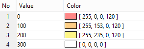
For example, using the color table above the following colors will be selected:
If the aircraft is below the ground the red color is selected.
If the aircraft is 100m or closer to the ground the red color is selected.
If the aircraft is between 100m and 200m from the ground the orange color is selected.
If the aircraft is between 200m and 300m from the ground the yellow color is selected.
If the aircraft is more than 300m from the ground the last, in this case fully transparent, color is selected.
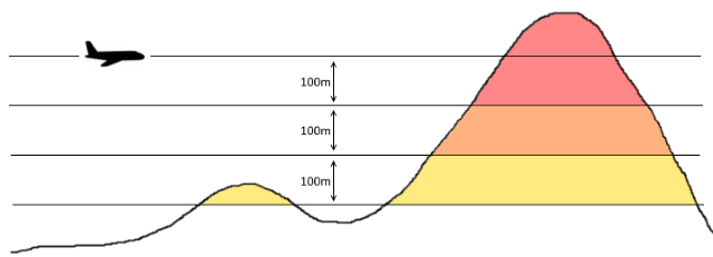
Or demonstrated in picture form:
 |
As can be seen above it is often a good idea to reserve one entry to a completely transparent color (or use the MaxDistance property to limit the area over which the terrain warning is rendered).
This property and the color table returned by it are not thread-safe. If you need to update the color table at runtime either do it from the GUI thread or clone the active TerrainWarningOverlay object, update it and then replace the one assigned to View.TerrainWarningOverlay.
Platforms
Windows, Linux, Android